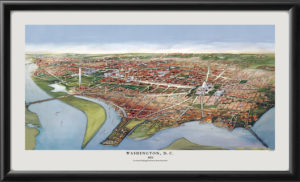
Restored panoramic pictorial map of Our Nation’s Capital – Washington, D.C. produced in 1948 by Henrietta Lintner, showing streets, rivers, parks, railroad lines and featured buildings – listed in a numbered key along the margins – as well as federal and municipal buildings, national and international organizations, institutions, stores, theaters, hotels, restaurants, clubs, boat slips, and steamboat lines.
