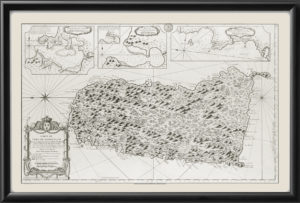
Restored bird’s eye view map of St. Lucia, 1794, from surveys made by Thomas Jeffreys, Geographer to the King of England. Includes an inset of plan of Carenage – renamed Castries.
$39.95 – $44.95
Our maps are shipped to you unframed. We show them as framed images for illustration purposes only.
20×24, 24×30
The results below are a partial list of maps, for a full listing please visit Shop by State or Shop by Country.
