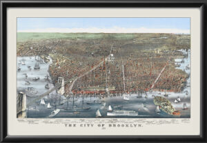
Restored bird’s eye map of New York City, 1879 by Will L. Taylor, depicting the entire length of the island of Manhattan, and surrounded by period advertisements and portraits of various businesses in New York and New Jersey. The original map was 74 x 42 inches, printed on four 38 x 22 inch sheets. Original prints sold for $10. The Taylor Map was one of the first true attempts to label all roads and piers and to depict buildings using a vanishing perspective.